In part I, I stopped just as we were beginning to explore the palace.
First, a little fun with windows. Here is the East Palace (44) as seen from the courtyard (40):
Different angle, same window (it was the most photogenic):
Going down into the East Palace, we have some old stone carvings:
That's one of the castle's former coat of arms.
Exploring further:
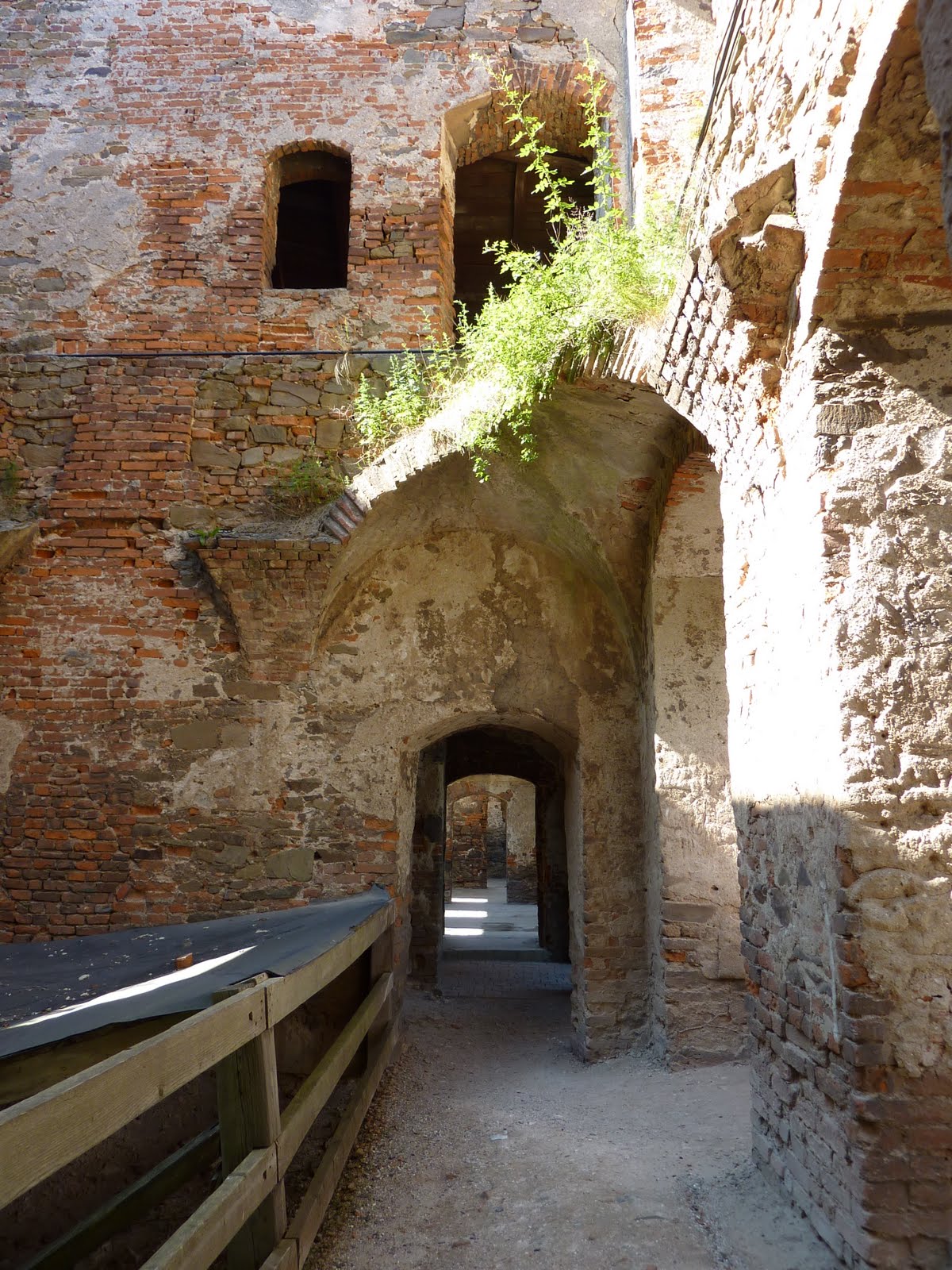
This room is near the corner of the East and North (43) Palace:
And here's a close up of that modern statue:
As we come around under the North palace and climb the stairs, we have a nice view of the East Palace and unnumbered tower.
A little to the right:
That window in the center is where I photographed the kitchen in Part I.
Exploring the North Palace:
On the map there is a structure outlined in brown beside the Palace and #43. Standing there and looking south, we can see the Hussite Tower (35).
The metal 'pipes' at center are for the smiths and their fires (modern, of course). The grassy strip leading away from this door is the road to the cemetery (42). You'll see it again when we climb the tower.
Now, if I ever catch someone graffiti-ing or carving on a castle, I will bop them on the head with my water bottle, which may or may not be empty. At least this time it is just the wood. I have no idea why people need to mark things like dogs. Go learn some actual craft and leave your mark on the world that way, people!
*ahem* Moving along. We can make our way along to the corner of the North and East Palace and out onto the terrace (47- the long triangle in silver):
The north edge of the outer wall:
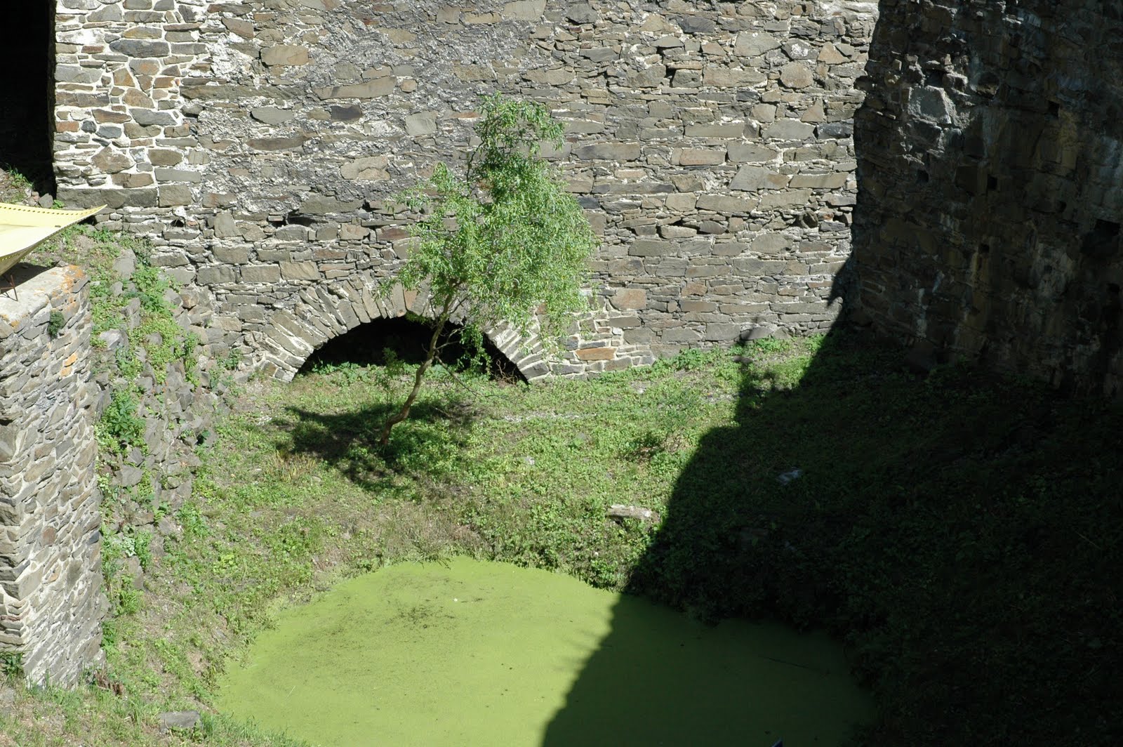
You can see the moat was pretty sizable here as well. This moat isn't labeled on the map, but the 'Devil's abyss' well (30) sits within it. I'm not certain what part of the moat was used as a cemetery.
Stepping back inside the East Palace:
Exiting the Palace and returning to the Fourth Courtyard (32), we have an entrance beside the Hussite Tower:
Again, those walls were impressively thick.
And here's the tower; I try to save them for last so I can see what I've explored:
First, a general scenery shot:
Now the newest part of Helfštýn, sprawling out below me:
That's the stables with the red roof.
To the left, we have the north edge of the large second courtyard:
And a little more left, the tower by the former entrance (24):
I've just cut off the inner end of the fourth gate in the bottom left of the above photo.
Further further left, and leaning out the tower, we can see the fifth gate (37), remains of the tower, the palace, et al.
Even more stunning, here's the full view of the palace, thanks to a friend who stitched two pictures for me in photoshop:
And the classic 'looking straight down' shot, from the back of the tower:
Nice.
So, climbing back down to the courtyard, we can take a closer look at the smithy (28):
The above photo shows about a third of the room.
Standing under the arch of the 3rd gate (20) and climbing on the wall and gate, we have this view:
I took a similar shot in Part I, but couldn't resist another.
Exiting the second gate (10):
Here's the tower by the first gate and tower (6):
And a little left, the openings for the cannons:
The next few photos were taken as I strolled around the castle:
Second gate tower.
Thou shall not pass!
And, driving away, we see just how sprawling the castle is, and how much the terrain changes:
That's the palace, Hussite tower, second and first gate towers.
Thus ends my tour of Helfštýn. I hope you enjoyed it.
One last item of interest. On the way, we passed Hrad Stary Jicin:
I returned here at the end of my trip, and will be posting on these ruins soon.
Friday, July 23, 2010
Sunday, July 18, 2010
Hrad Helfštýn
Fortification: Castle Helfštýn
Location: Helfštýn, Czech
Built: Beginning of the 14th century.
Remaining original structures: Many ramparts and stone walls.
Helfštýn is another expansive castle, and it was also once part of the Amber Road or Trail. If I'd known ahead of time I'd be coincidentally going along the Amber Trail, I would have read up more. I'll definitely get a book from the library when I get home.
Helfštýn has a long history of changing hands and being expanded, with much of the construction occurring around the turn of the 15th century. After the Thirty Years' War, the owners did not want to pay the castle garrison and in 1656 a court council ordered the castle demolished in order to prevent rebels from settling there. They considered the castle 'useless and deleterious'. It's a shame they thought so, but luckily they didn't do a very thorough job of destroying the castle.
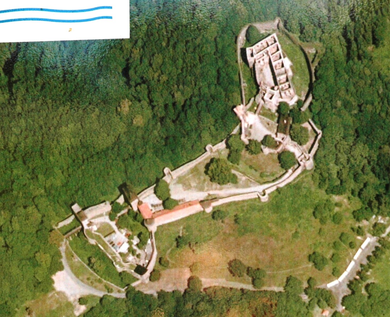
On with the tour. First, here are two pictures of overhead shots, posted near the gate:
The main parking lot sits just below the castle on the south side, so I only had to walk to the opposite end to enter the first gate.
This is one southwest corner of the castle, as I'm walking up to the main gate:
Same stretch of wall, below. There's still plenty of castle to my left...
(As an aside- the background image for my title is a section of this wall).
A little further along, as we round the corner to the gate, we have this tower:
And that's the gate to the left, partially hidden behind the metal structure.
I should note that Helfštýn is host to several international blacksmith events, and thus there is a lot of metal work inside the castle, and some outside. Mostly it was very nice, including that sign I posted at the start, but sometimes it was cluttering all my shots! In case you haven't noticed, I take my photography seriously ;)
Back to the tour, I can now show you the main gate:
Nice, and simple, and effective. And the moat certainly does a good job as well:
If I recall correctly, the moat was once a fair bit deeper. It did not hold water, nor did any other moat except the second. Every gate had a moat and a draw bridge before it in the past.
So, stepping within the castle and pausing to show you the door:
Let me show you the map so you can follow along. It's a rather nice one, thankfully:
The translation for most those numbers:
1) Former castle gate (2-4 are also former structures- note the striping). 5) First moat. 6) First gate. 7) Thick/wide wall with 2 towers and 2 bastions. 96m long, 7-9m thick, 12.6 to 14.5m high. Built 1st half of 16th century. 8) First courtyard. 9) Second moat, with water. 10) Second gate (yr. 1480). 11) Former guardhouse. 12) Former stables; now a restaurant. 13) Former outbuildings. 14) Second courtyard. 15) Bastion built with cistern. 16) Former Hussite's moat (and currently there is a moat there). 17) Former Hussite rampart or wall. 18) Cannon bridge (possibly meaning it went to the cannon post or ground which is #19. 20) Third gate. 21) Former third gate. 22) Former barbican or gate tower. 23, 24) Former square tower with full opening into the castle. Pre 1468. (Note, it says 'former' but the tower is still there. Also, my native Czech speakers couldn't quite make out what was written on the map and we had to go read up on the website to learn a little more). The square tower was called Kostka's tower.
Half way there! 25) Third courtyard. 26) Kennel and underground corridor. 27) Fourth gate. There was a moat here previously. 28) Smithy. 29) Bakery with road to well. 30) Well. Once 150m deep and called 'Devil's abyss' or similar. 32) Fourth courtyard. 33) Fifth moat. 34) Deep pond (Note: Number is hard to read. The pond sits within the fifth moat). 35) Hussite tower. 37) Fifth gate, which sits within the tower. 39) Kitchen. 40) Palace courtyard. 42) Road to cemetery. 43) North Palace. 44) East Palace. 45) Oldest church. 46) North Palace terrace. 47) East Palace terrace. 48) Oldest walls
S is for North in Czech, by the way.
On the right end of the map is a color code that shows when which section was built. Unfortunately, some of the colors are very similar, but if you start at the palace and work your way out, you won't be too far off. Also: Stol = Century. Pol = 1st half. 2 Pol = 2nd half.
As always, I suggest you open the map(s) in a new window so you can follow along during the tour. Numbers below in parenthesis refer to map numbers.
Here is the second gate (10), below. You can see the smaller door beside it. This gate, tower, and second courtyard (14) wall were built by William of Pernstein in 1480.
And here's a closeup of that small door:
This is the rest of the first courtyard (8) and the second moat (9):
I'm uncertain what those buildings used to be, but there used to be water there, so perhaps they are modern. Keep in mind this last addition to the castle was built in the 17th century. The wide wall (7) is to the right of course, and I'll show you a little more of it on the way out. As I understand it, the wide wall was built before the order to demolish the castle was made. I can't imagine they spent a lot of time trying to take down that wall. The map shows many former structures in that area, like the bastion, which I imagine were victims of the demolition.
Walking through the second courtyard, we soon see the Hussite tower (35):
The second courtyard was once used for daily living and household purposes. The stables (12) are located here, but the building now serves as a restaurant. (And at the far end, the public bathrooms)
At the end of the second courtyard, we have the back of the smithy (28) and fourth courtyard (32) wall:
Looking slightly right, we have the smithy again, an unnamed building, and the third gate:
The third gate once had it's entrance to the right of the current one (21), but it has been walled off:
The change in the gates was made by William of Pernstein.
Backing up a little, here is a bastion, near the third gate (20) and the 'cannon' bridge (18):
Pretty solid. The walls around the castle are all about 7 meters thick (with the wide wall being 9m).
Stepping through the third gate and turning back around, we have this lovely scene:
Turning right from that position, we have the fourth gate (27) just uphill of us.
Note that little door, down the steps on the right. That led to the kennel (26), which I'll show you in a second.
The fourth gate was built in the (first? half of the) 14th century by the noblemen from Kravaře, and later rebuilt by the Persteins in the 15th century. The moat was filled in during demolition in 1656. In recent times, the ground has eroded and you can see where the original level was, at the base of those two projections in the arch. Those foot-stones directed the wheels of horse drawn carriages. Pretty handy, but quite the speed bump if you're not centered!
Here is the spacious kennel; sorry I couldn't get a better shot:
Up to 80 hunting dogs were kept here, which is an impressive number.
It wasn't until I got home and got proper help in translating the map, that I learned about an underground corridor that ran under here. There is nothing in the English written mini-tour guide about this. Nor did the Czech speaking tour guide mention it when we walked the ground floor of the palace, afaik. Something for further research I think, when I have time, as it sounds interesting.
Moving forward, the third courtyard (25) was also important for daily living. It held the smithy and bakery. More on this toward the end of the tour, as we come back through the courtyard.
As you walk into the third courtyard, the Hussite tower (35) immediately catches your eyes:
Lovely, no? This tower served as a lookout.
Turning to the right, we have the fifth gate (37), towers, and palace walls.
Another angle:
And a close up of the gate:
Pausing on the now-stone bridge to look down into the moat:
That's the deep pond, which was a cistern for the kitchen. There was a story (and forgive me for giving the short version) about how the lord of the castle wanted to sleep with all the women who staid at the castle. One woman fled and leapt from the castle into the pond and drowned. Apparently this is a common event or a popular legend, as Hukvaldy had a similar tale. Also, should you find yourself transported to medieval times, know that going after the wrong women can find you on the inside of a wall and trapped in stone until you die. On the bright side, your ghost can haunt the castle forever.
So, walking forward, we can pause between the fifth and sixth (not numbered on map) gate and look up through the skeleton of the tower.
Nice. That was a good tower at one point in time. And while I didn't get the height, it was once 10 meters higher than it is now, and called 'Giant' or 'Bugler'. I believe it was once the highest castle tower in the 15th century, but don't quote me on that as I'm going off a poorly written translation. But I can tell you that in 1817 they were concerned the tower would collapse and so they shot it to pieces with cannons. What a waste.
So, entering the Palace Courtyard (40) and looking to the North Palace (43):
I imagine folks lived in style here once :) For those still following on the map- it's a bit of a meshwork due to all the changes over time. I'll try to keep you oriented as we go.
Here's a small door on the East Palace (44). There's a small room in there, now a mint. I didn't catch what it was historically.
This is the remains of a kitchen, where they are doing restorations, as seen through a window:
This is the unnumbered circular tower on the south end of the palace:
And this is where I will leave off for now. More on this large castle in Part II, once I'm back in the US.
Part II: http://polskizamki.blogspot.com/2010/07/helfstyn-part-ii.html
Location: Helfštýn, Czech
Built: Beginning of the 14th century.
Remaining original structures: Many ramparts and stone walls.
Helfštýn is another expansive castle, and it was also once part of the Amber Road or Trail. If I'd known ahead of time I'd be coincidentally going along the Amber Trail, I would have read up more. I'll definitely get a book from the library when I get home.
Helfštýn has a long history of changing hands and being expanded, with much of the construction occurring around the turn of the 15th century. After the Thirty Years' War, the owners did not want to pay the castle garrison and in 1656 a court council ordered the castle demolished in order to prevent rebels from settling there. They considered the castle 'useless and deleterious'. It's a shame they thought so, but luckily they didn't do a very thorough job of destroying the castle.
On with the tour. First, here are two pictures of overhead shots, posted near the gate:
The main parking lot sits just below the castle on the south side, so I only had to walk to the opposite end to enter the first gate.
This is one southwest corner of the castle, as I'm walking up to the main gate:
Same stretch of wall, below. There's still plenty of castle to my left...
(As an aside- the background image for my title is a section of this wall).
A little further along, as we round the corner to the gate, we have this tower:
And that's the gate to the left, partially hidden behind the metal structure.
I should note that Helfštýn is host to several international blacksmith events, and thus there is a lot of metal work inside the castle, and some outside. Mostly it was very nice, including that sign I posted at the start, but sometimes it was cluttering all my shots! In case you haven't noticed, I take my photography seriously ;)
Back to the tour, I can now show you the main gate:
Nice, and simple, and effective. And the moat certainly does a good job as well:
If I recall correctly, the moat was once a fair bit deeper. It did not hold water, nor did any other moat except the second. Every gate had a moat and a draw bridge before it in the past.
So, stepping within the castle and pausing to show you the door:
Let me show you the map so you can follow along. It's a rather nice one, thankfully:
The translation for most those numbers:
1) Former castle gate (2-4 are also former structures- note the striping). 5) First moat. 6) First gate. 7) Thick/wide wall with 2 towers and 2 bastions. 96m long, 7-9m thick, 12.6 to 14.5m high. Built 1st half of 16th century. 8) First courtyard. 9) Second moat, with water. 10) Second gate (yr. 1480). 11) Former guardhouse. 12) Former stables; now a restaurant. 13) Former outbuildings. 14) Second courtyard. 15) Bastion built with cistern. 16) Former Hussite's moat (and currently there is a moat there). 17) Former Hussite rampart or wall. 18) Cannon bridge (possibly meaning it went to the cannon post or ground which is #19. 20) Third gate. 21) Former third gate. 22) Former barbican or gate tower. 23, 24) Former square tower with full opening into the castle. Pre 1468. (Note, it says 'former' but the tower is still there. Also, my native Czech speakers couldn't quite make out what was written on the map and we had to go read up on the website to learn a little more). The square tower was called Kostka's tower.
Half way there! 25) Third courtyard. 26) Kennel and underground corridor. 27) Fourth gate. There was a moat here previously. 28) Smithy. 29) Bakery with road to well. 30) Well. Once 150m deep and called 'Devil's abyss' or similar. 32) Fourth courtyard. 33) Fifth moat. 34) Deep pond (Note: Number is hard to read. The pond sits within the fifth moat). 35) Hussite tower. 37) Fifth gate, which sits within the tower. 39) Kitchen. 40) Palace courtyard. 42) Road to cemetery. 43) North Palace. 44) East Palace. 45) Oldest church. 46) North Palace terrace. 47) East Palace terrace. 48) Oldest walls
S is for North in Czech, by the way.
On the right end of the map is a color code that shows when which section was built. Unfortunately, some of the colors are very similar, but if you start at the palace and work your way out, you won't be too far off. Also: Stol = Century. Pol = 1st half. 2 Pol = 2nd half.
As always, I suggest you open the map(s) in a new window so you can follow along during the tour. Numbers below in parenthesis refer to map numbers.
Here is the second gate (10), below. You can see the smaller door beside it. This gate, tower, and second courtyard (14) wall were built by William of Pernstein in 1480.
And here's a closeup of that small door:
This is the rest of the first courtyard (8) and the second moat (9):
I'm uncertain what those buildings used to be, but there used to be water there, so perhaps they are modern. Keep in mind this last addition to the castle was built in the 17th century. The wide wall (7) is to the right of course, and I'll show you a little more of it on the way out. As I understand it, the wide wall was built before the order to demolish the castle was made. I can't imagine they spent a lot of time trying to take down that wall. The map shows many former structures in that area, like the bastion, which I imagine were victims of the demolition.
Walking through the second courtyard, we soon see the Hussite tower (35):
The second courtyard was once used for daily living and household purposes. The stables (12) are located here, but the building now serves as a restaurant. (And at the far end, the public bathrooms)
At the end of the second courtyard, we have the back of the smithy (28) and fourth courtyard (32) wall:
Looking slightly right, we have the smithy again, an unnamed building, and the third gate:
The third gate once had it's entrance to the right of the current one (21), but it has been walled off:
The change in the gates was made by William of Pernstein.
Backing up a little, here is a bastion, near the third gate (20) and the 'cannon' bridge (18):
Pretty solid. The walls around the castle are all about 7 meters thick (with the wide wall being 9m).
Stepping through the third gate and turning back around, we have this lovely scene:
Turning right from that position, we have the fourth gate (27) just uphill of us.
Note that little door, down the steps on the right. That led to the kennel (26), which I'll show you in a second.
The fourth gate was built in the (first? half of the) 14th century by the noblemen from Kravaře, and later rebuilt by the Persteins in the 15th century. The moat was filled in during demolition in 1656. In recent times, the ground has eroded and you can see where the original level was, at the base of those two projections in the arch. Those foot-stones directed the wheels of horse drawn carriages. Pretty handy, but quite the speed bump if you're not centered!
Here is the spacious kennel; sorry I couldn't get a better shot:
Up to 80 hunting dogs were kept here, which is an impressive number.
It wasn't until I got home and got proper help in translating the map, that I learned about an underground corridor that ran under here. There is nothing in the English written mini-tour guide about this. Nor did the Czech speaking tour guide mention it when we walked the ground floor of the palace, afaik. Something for further research I think, when I have time, as it sounds interesting.
Moving forward, the third courtyard (25) was also important for daily living. It held the smithy and bakery. More on this toward the end of the tour, as we come back through the courtyard.
As you walk into the third courtyard, the Hussite tower (35) immediately catches your eyes:
Lovely, no? This tower served as a lookout.
Turning to the right, we have the fifth gate (37), towers, and palace walls.
Another angle:
And a close up of the gate:
Pausing on the now-stone bridge to look down into the moat:
That's the deep pond, which was a cistern for the kitchen. There was a story (and forgive me for giving the short version) about how the lord of the castle wanted to sleep with all the women who staid at the castle. One woman fled and leapt from the castle into the pond and drowned. Apparently this is a common event or a popular legend, as Hukvaldy had a similar tale. Also, should you find yourself transported to medieval times, know that going after the wrong women can find you on the inside of a wall and trapped in stone until you die. On the bright side, your ghost can haunt the castle forever.
So, walking forward, we can pause between the fifth and sixth (not numbered on map) gate and look up through the skeleton of the tower.
Nice. That was a good tower at one point in time. And while I didn't get the height, it was once 10 meters higher than it is now, and called 'Giant' or 'Bugler'. I believe it was once the highest castle tower in the 15th century, but don't quote me on that as I'm going off a poorly written translation. But I can tell you that in 1817 they were concerned the tower would collapse and so they shot it to pieces with cannons. What a waste.
So, entering the Palace Courtyard (40) and looking to the North Palace (43):
I imagine folks lived in style here once :) For those still following on the map- it's a bit of a meshwork due to all the changes over time. I'll try to keep you oriented as we go.
Here's a small door on the East Palace (44). There's a small room in there, now a mint. I didn't catch what it was historically.
This is the remains of a kitchen, where they are doing restorations, as seen through a window:
This is the unnumbered circular tower on the south end of the palace:
And this is where I will leave off for now. More on this large castle in Part II, once I'm back in the US.
Part II: http://polskizamki.blogspot.com/2010/07/helfstyn-part-ii.html
Friday, July 16, 2010
Coming soon
Well, I have my post on Strečno half done, but I think I have a map on my entry ticket and that would be really helpful as Strečno is really complicated a little castle. Hopefully I will get that sorted and finished in the next few days.
Meanwhile, I'll be working on Helfštýn. Hopefully that will be up by tomorrow night.
Until then, some random photos:
This is the ruins of a castle near Strečno, which now sits in a park. I didn't get closer due to a storm on the horizon and road difficulties.
You have to watch out for falling rocks, and it's a shame the castle is not being repaired or at least conserved. There are so many castles in the area, however, I suppose you can't save them all.
Meanwhile, I'll be working on Helfštýn. Hopefully that will be up by tomorrow night.
Until then, some random photos:
This is the ruins of a castle near Strečno, which now sits in a park. I didn't get closer due to a storm on the horizon and road difficulties.
You have to watch out for falling rocks, and it's a shame the castle is not being repaired or at least conserved. There are so many castles in the area, however, I suppose you can't save them all.
Subscribe to:
Posts (Atom)